
Iceland is one of the only places on Earth where a mid-ocean ridge rises above sea level, which means you can actually walk, drive, or snorkel across the boundary between two tectonic plates. This guide explains where that boundary is visible, what you're really looking at geologically, and how to plan the drive if you want to see it for yourself.
Short answer
Iceland sits directly on the Mid-Atlantic Ridge, the boundary between the North American and Eurasian tectonic plates. The clearest place to see this is Þingvellir National Park, about 50 km east of Reykjavik, where the Almannagjá fissure marks the edge of the North American plate. You can also see the ridge come ashore on the Reykjanes Peninsula, and trace its volcanic effects further afield at Lakagígar in the south, though that site is only reachable by 4x4 in summer.
What are the tectonic plates in Iceland, exactly?
Iceland is split by the boundary between the North American plate and the Eurasian plate. The two plates are moving apart at roughly a couple of centimetres a year, and the country is essentially being stretched along that line, which is also why Iceland has so much volcanic and geothermal activity.
Most of this boundary lies underwater, running the length of the Atlantic Ocean floor as the Mid-Atlantic Ridge. Iceland is the one place where a large section of that ridge sits on dry land, so the rift valleys, fissures, and volcanic fields you see driving around the country are direct, visible evidence of plate tectonics rather than something you have to take on faith.
This is also why people sometimes call the line an "Iceland continental divide", it's not a divide of water flow like the one in the Rockies, but a divide between two continental plates that happens to run straight through the country.
Where can you see the tectonic plates in Iceland?
| Location | What you actually see | Best season to visit | Access |
|---|---|---|---|
| Þingvellir National Park | Almannagjá fissure and rift valley marking the edge of the North American plate; Silfra fissure for snorkelling/diving | Year-round, road conditions vary in winter | Paved road (Route 36) from Reykjavik, roughly 50 km |
| Reykjanes Peninsula (Bridge Between Continents) | A footbridge over a fissure where the ridge reaches land, near Grindavík | Year-round | Paved roads, close to Keflavik Airport |
| Lakagígar / Bárðarbunga area | Volcanic craters and fissures formed along the Mid-Atlantic Ridge | Summer only, typically opens mid-to-late June depending on conditions | F206, 4x4 required, no bridges over rivers on the approach |
Conditions and opening dates for highland roads change every year, so always check umferdin.is and safetravel.is before heading out, especially for Lakagígar.
Þingvellir National Park tectonic plates, the classic view
Þingvellir is the single most reliable place in Iceland to see the plate boundary, and it's an easy half-day trip from Reykjavik on paved roads. Standing in Almannagjá, the dramatic rock canyon that runs through the park, you are standing on the edge of the North American plate, looking across the rift toward the Eurasian side.
Þingvellir is a UNESCO World Heritage Site, partly for its geology and partly because it was the site of Iceland's original parliament, founded in 930 AD. The rift valley itself is technically widening every year as the two plates pull apart, which is a strange thing to process while walking through it.
If you want to go beyond looking and actually get in the water, Silfra is a narrow fissure within the park filled with glacial meltwater so clear that visibility often exceeds tens of metres. Snorkelling or diving Silfra means swimming in the gap between the two continents, a popular add-on for visitors combining the Golden Circle with a self-drive itinerary.
Reykjanes Peninsula, where the ridge reaches land
The Reykjanes Peninsula, just south of Keflavik Airport, is where the Mid-Atlantic Ridge visibly comes ashore. It's a quieter, less-visited alternative to Þingvellir for seeing the same geological boundary.
Near Grindavík, a small footbridge, locally known as the Bridge Between Continents, spans a fissure and lets you walk from the North American side to the Eurasian side in a few steps, which makes for a straightforward photo stop if you're picking up or dropping off a rental car near the airport. Since the peninsula sits directly on the ridge, it's also one of the more volcanically active parts of the country, so it's worth checking vedur.is, the Icelandic Met Office, for any current activity advisories before a visit.

Lakagígar and the Mid-Atlantic Ridge volcanoes
Lakagígar (the Laki craters) and Bárðarbunga sit within the Mid-Atlantic Ridge system, and while you're not looking at a clean rift like Almannagjá, you're looking directly at the consequence of the plates pulling apart, a long chain of volcanic fissures and craters. Iceland's active volcanoes cluster along this ridge for exactly that reason.
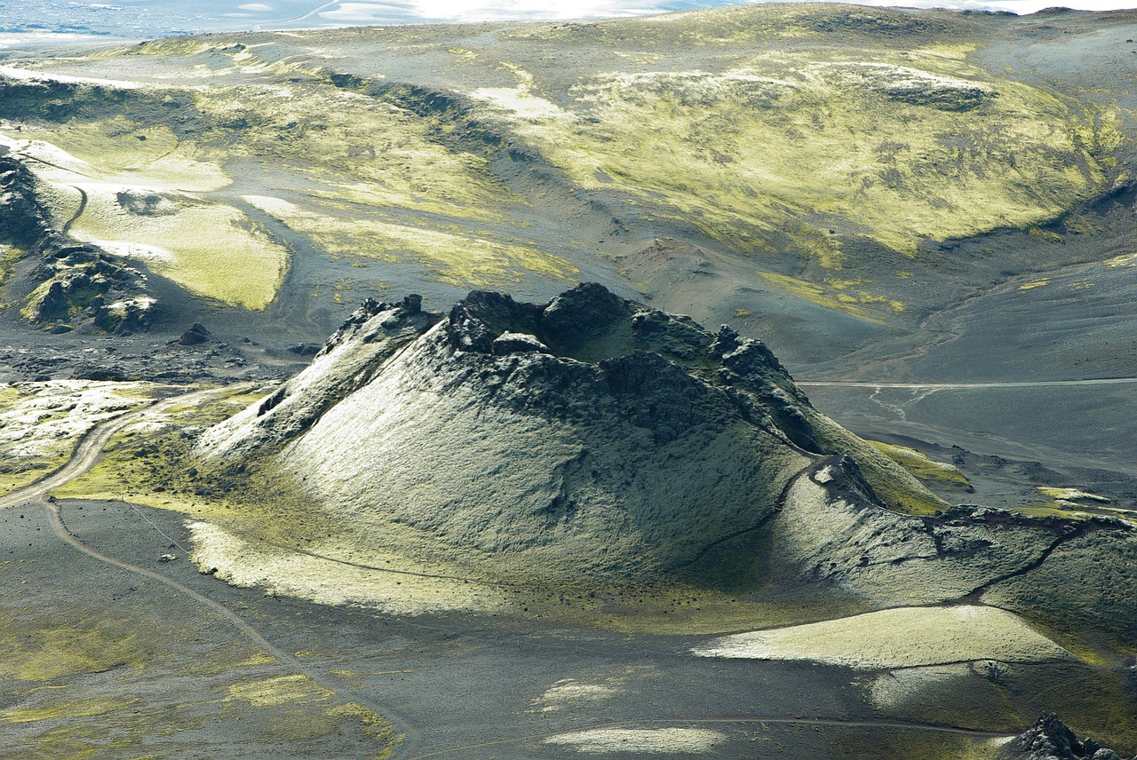
Lakagígar is only accessible during summer, typically via the F206, and requires a 4x4, there's no route in by 2WD car, and the approach involves unbridged sections that can vary year to year. If highland driving like this is part of your plans, it's worth reading through our F-road driving guide and our 4x4 decision guide before booking, since the right vehicle for the Ring Road is not necessarily the right vehicle for the highlands.
Can you see the tectonic plates moving apart?
Not in real time, the movement is only a few centimetres a year, far too slow to observe directly. What you can see is the physical evidence of that movement: rift valleys, fissures, and stretched-open cracks in the land, most clearly at Þingvellir, where the widening canyon of Almannagjá is a visible record of decades and centuries of gradual separation.
Getting there by car
All three main sites are reachable in a standard rental car except Lakagígar, which needs a 4x4. Þingvellir and the Reykjanes Peninsula sit on paved, well-maintained roads and are easy additions to a Golden Circle day trip or an airport-to-Reykjavik drive, in a 2WD car in summer or a well-equipped vehicle in winter conditions, see our winter driving guide if you're visiting outside the summer months.

If Lakagígar or other highland routes are on your itinerary, it's worth choosing a 4x4 from the outset rather than upgrading later, and checking what's included in terms of gravel and off-road cover, since Iceland's F-roads and gravel tracks are harder on a vehicle than paved roads. Picking up at Keflavik Airport is straightforward with online check-in, and Blue Car Rental's range of vehicles covers everything from a compact 2WD for a Golden Circle day out to a 4x4 built for highland tracks.
Mistakes to avoid
Don't assume a 2WD rental will get you to Lakagígar, the F206 requires a 4x4, and driving an unsuitable vehicle off paved roads is not something any Icelandic rental insurance is designed to cover. Don't skip checking umferdin.is before a highland trip, since opening dates for F-roads shift from year to year depending on snowmelt. And don't treat river crossings on the way to volcanic sites like Lakagígar casually, if you're unsure about a crossing, the safest choice is always to turn back and check current conditions on safetravel.is, or consider joining an experienced local operator instead of self-driving that particular stretch.

 CAN YOU DRINK TAP WATER IN ICELAND?